
Wednesday 17th August. Storm damage on the River Greta. Leader Alan Wise.
Meet 6.30pm at Booths car park, Keswick. CA12 5NZ (GR NY 26326) Wellingtons recommended.
Wednesday 17th August. Storm damage on the River Greta. Leader Alan Wise.
Meet 6.30pm at Booths car park, Keswick. CA12 5NZ (GR NY 26326) Wellingtons recommended.
At the end of a wet day, ten members gathered on Beacon Hill, Penrith on a surprisingly fine evening. John Rodgers set the scene by describing the landscape features to the west of Penrith, well seen from this vantage point. The party then proceeded to Cowraik Quarry where Fi Harwood drew attention to the drumlinoid topography in the immediate foreground. The cover for the drilling for water supplies in the 1976 drought was noted and local water supply and sources discussed. Fi then led us up to the first exposure of Penrith Sandstone, and here a deep red very poorly cemented rock. The hematite coated grains were the well rounded and the rock very friable. We then proceeded to the first of two major faces in the disused quarry. The first displayed large scale cross-bedding, typical of barchan sand dunes, though it was difficult to determine just how many dunes could be identified. John Rodgers had nobly carried a bag of sand and treated the party to a practical demonstration of the formation of the dunes. Fi drew our attention to the approximately horizontal mineralized striations on two vertical faces. Considerable discussion ensued as to whether these were the slickensides and precisely how they were formed.
At the second major quarry face the sandstone was more blocky. Graded bedding could be identified within the dunes. More ‘slickensides’ were observed and more discussion, particularly on the formation of the mineralization along these surfaces ensued. The grains from this quarry were particularly well rounded “millet seed” quartz. Discussions of provenance of the grain, deemed to come from the south, and the processes of cementation concluded the evening before the party returned to the cars and thanked Fi and John for a most interesting evening.
An evening excursion into the Penrith Sandstone with dune bedding features, faulting and panoramic views over the Lakeland fells. 2km walk on rough track; short steep descent.
Meet 18.30 at cemetery entrance, Beacon Edge (NY517311)
15 members spent an excellent day under the very able leadership of Noel Pearson to the two current Carboniferous Stage Stratotype sites in Cumbria. Both have recently been the subject of a great deal of new research by specialist palaeontologists, focussed not only on the macro fauna, but on advances in the field of micro fossils.
The leader gave members an excellent summary of the history of research on these two sites and an update on recent findings. Each stage has a basal boundary defined at a specific point in the marine rock section. Stages are chronostratigraphical (time
units). We are fortunate here in east Cumbria to have these two classic sites a short distance apart. The Asbian basal boundary at Little Asby Scar (NY 699083) and the Brigantian at Janny Wood, south of Kirkby Steven (NY 783038).
The morning was spent walking up the Potts Beck valley to the Little Asby Scar location. A short climb up the Scar brought us to the key exposure – a clean rocky scar section where the Stage junction is currently defined. Yellow markings on the cliff face and the obvious signs of coring either side of the junction mark the spot. The finer points of the palaeontology are not obvious in the field, but the whole site is remarkably fossil rich. Some magnificent specimens of corals and sponges kept members occupied for some time. Some unusual dark bands of material also stretched member’s minds. The geomorphological features of the wider region were discussed from the scarp top, which affords excellent views over the karst terrain, the spectacular meandering Potts Beck and the Howgill Fells to the south. The rather complex recent drainage and glacial history of the area was discussed.
A short drive eastwards for the afternoon session brought us to the River Eden Valley and the type section of the Brigantian in the steeply dipping beds exposed along the river bed. A detailed log of the beds was provided to view the section as the group walked upstream from a notable series of waterfalls in the river below the wood. En route we were introduced to a new term at Catagill Scar – a ‘stratomorph’ – an exposed bedding plane surface which now forms a 45º slab of rock on the west bank of the Eden. Rather heavy rain somewhat shortened deliberations on this site, but the day as a whole was an insight to members on how very detailed palaeontology is enabling these sections to be logged and interpreted.
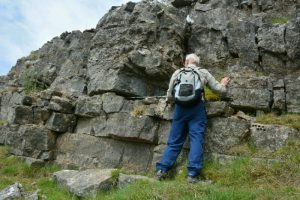
Leader Noel Pearson at the Little Asby Scar site – walking pole to his left lying horizontally at the base of the Asbian.
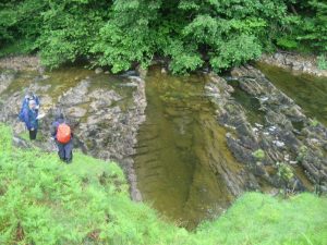
Janny Wood site. Carboniferous beds dipping upstream (to right in the view). The Brigantian boundary is at the extreme right of the picture.
The party met on the open fell at 6.30pm on a fine sunny evening. John Rodgers, our leader, began by describing the features of the Lowther Valley to the south. This valley is bordered on the east by Carboniferous limestone escarpments and on the west by the rugged terrain of the Borrowdale Volcanics. Between the two the relatively easily eroded Skiddaw Group rocks occur and underlie the lower part of the valley.
We then walked northwards over the fell, noticing sink holes and one small exposure of the limestone. We crossed the narrow sandstone band of the Ravonstonedale Group, which is very poorly exposed but members located a few specimens of the well-sorted, gingery coloured sandstone. A pause was made to consider a line of enigmatic depressions which were probably man made rather than sink holes. The party continued to Heughscar Hill to enjoy the magnificent view along Ullswater. Again the underlying geology was reflected in the topography. Here the BVG group form the high rugged fells to southern and southeastern boundaries of the Lake. To the north west Great Mell Fell and Little Mell Fell and the smaller fells of Soulby Fell and Bowerbank are smooth, rounded hills of the Mell Fell Conglomerate. Closer to the viewpoint the low land is again a reflection of the erosion of the Skiddaw Group rocks which underlie this area.
From this panorama the group moved eastwards to a small exposure of limestone pavement and a tumbledown limestone wall where a range of fossils – colonial and solitary corals, and a variety of brachiopods – were identified.
This was the last stop after which the party returned to the cars and thanked John for a very enjoyable evening.
This is an explanation of the Carboniferous Limestone successions that merited a visit in Oct. 2015 by an international group of geologists. AM walk to Asby Scar on fairly level rough track; PM level walk to Janny Wood with descent to river (Wellies useful). Total c. 5km walk.
Meet 10.30 Roadside 300m N of Mazon Wath farm (NY686086)
Leader: Noel Pearson